
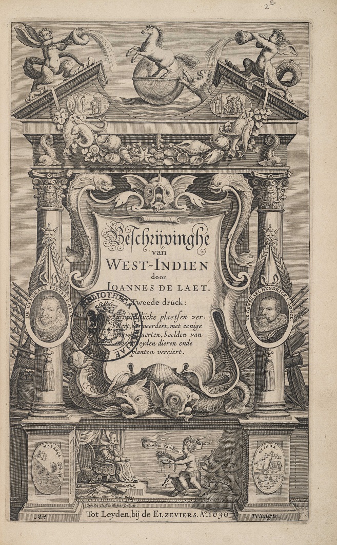
Student Contributions
Introduction • Reader's Guide
In their contributions on the selected regions from the Atlas Maior, the students describe their initial exploratory findings. They studied how the indigenous peoples were described in the Atlas and offer possible explanations for these descriptions, as well as addressing the sources Blaeu used, focusing mainly on how recent – or outdated – they were. As mentioned, Blaeu frequently used outdated information. In each student’s contribution, suggestions are made for further reading, for instance about the region in question or about a larger, overarching theme, such as the way in which non-European indigenous peoples were systematically marginalized in early-modern literature. Each contribution starts with a number, the title of the map, and the title of the text as included in the Atlas Maior. The number refers to the nine volumes of C. Koeman’s Atlantes Neerlandici, an authoritative reference work for historical cartographers. The second volume in this series focuses on the folio atlases published by Willem Jansz. Blaeu and Joan Blaeu. The so-called ‘Koeman number’ allows you to easily locate the correct historical map. The title of the map should also help to find it, although it should be noted in this context that competing publishers tended to use the same map titles. In other words, the titles as such are not unique to the maps in the Atlas Maior. The titles of the contributions will point you in the right direction as far as locating the relevant passages in the volumes of the Atlas Maior are concerned. We have not used any page or folio references, since these may show (slight) differences in collation.
North Africa, by Jesper Bergsma
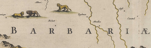
• Title of Map / Text: BARBARIA / Barbarien
• Koeman, Atlantes Neerlandici, vol. II, nr. 8610:2
‘Barbary’ refers to the coastal regions of North Africa. In Blaeu’s Atlas, it comprises the kingdoms of Morocco, Fez, Algiers, Tunes, and Tripoli, i.e. present-day Morocco, Algeria, Tunisia, and Libya. The region has a long and turbulent history with Europe. It was home to Carthaginian general Hannibal (247-183/2), who challenged the Romans in the Second Punic War. In Blaeu’s era, it were the Barbary pirates who caused turmoil raiding European merchant ships, capturing crews and cargo for ransom or slavery.
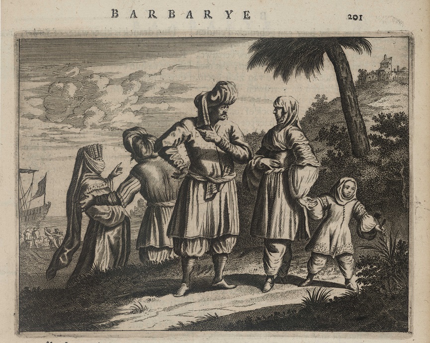
Since, initially, the captured seafarers were mostly Catholics, the Dutch Republic was largely indifferent. This changed when the Republic’s merchant vessels also started to be attacked and their crews enslaved. Interestingly, after having been captured, some Dutch seafarers turned into renegades — Europeans who converted to Islam and joined the Barbary pirates. They were important information brokers of maritime knowledge for the pirates.
This history might have affected the texts about Barbary in the Dutch edition of the Atlas Maior, in which Blaeu regularly uses negative descriptors and stereotypes to depict its inhabitants, calling them ‘grootspreckers’ [braggerts], ‘wantrouwigh’ [mistrustful], and ‘lichtgeloovigh in onzekere dingen’ [gullible]. Where did this mostly negative sentiment towards Barbary and its peoples come from? Was it due to the Barbary pirates who caused widespread fear and resentment? Or was it the European notion of religious, cultural, and moral superiority considered that it was a by and large Islamic region?
The cause is likely to be found in religious bias. Christian authors, which Blaeu as well used as his sources, often depicted Muslims as infidels and considered Islam a false religion. But could Blaeu perhaps have engaged in a certain degree of societal criticism? In a Calvinist environment, he took quite a bit of religious freedom by also publishing Catholic writings. Food for thought, or research, for that matter.
Further reading: Brood, P. (red.) 2018. De wijde wereld van Cornelis Pijnacker (1590-1645) . Zwolle: WBOOKS.
Canary Islands, by Suze van Dijken
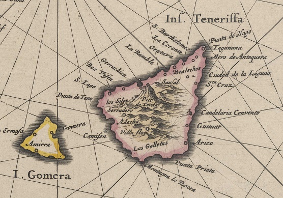
• Title of Map / Text: INSVLÆ CANARIÆ / De Canarische Eylanden
• Koeman, Atlantes Neerlandici, vol. II, nr. 8970:2
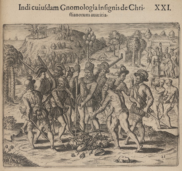
In Joan Blaeu’s time, the Canary Islands comprised the islands of Palma, Hierro, La Gomera, Tenerife, Gran Canaria, Fuerteventura, and Lanzarote. Blaeu did not attach much relevance to the smaller islands and left them unmentioned. Omitting information seems to be a trend in his text about the Canary Islands Blaeu included and the question is whether or not this was intentional.
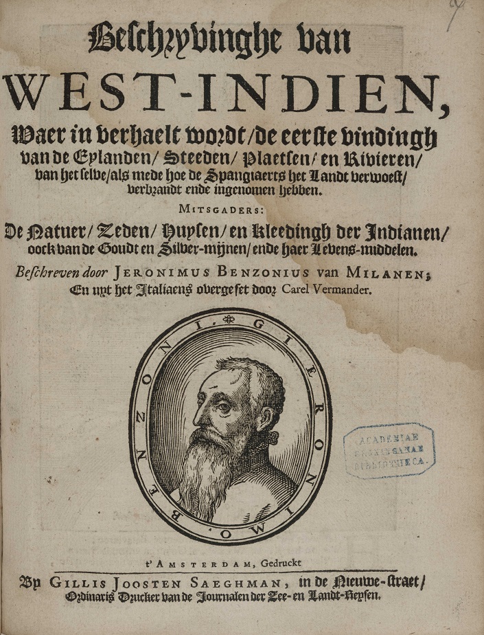
Blaeu does not, for instance, discuss Spain’s conquest of the islands. There is just one reference in his text to the alleged struggle between the Spanish and the indigenous peoples, whom he here calls ‘barbaren’ [barbarians], without addressing the process of conquest and colonization. Why did Blaeu not go into greater detail on these events? He definitely could have known what went on, for instance from the no fewer than eleven volumes of Historia del Mondo Nuovo [The History of the New World], a book by Girolamo Benzoni (c.1519-1572), (re)published several times between 1565 and 1727. In his book, Benzoni, an Italian historian and traveller, gives detailed first-hand accounts of the cruel Spanish colonial practices in America, criticizing the colonizers’ greed and brutal treatment of the indigenous population. In his chapter on the Canary Islands, Benzoni describes a number of violent clashes between the Spanish and the indigenous peoples. He wrote the following about the Rebellion of La Gomera (translated from the Italian): ‘Landing a hundred and twenty men there, they (the Spanish) were attacked with such courage and ferocity by the natives, that the greater part of them were killed.’
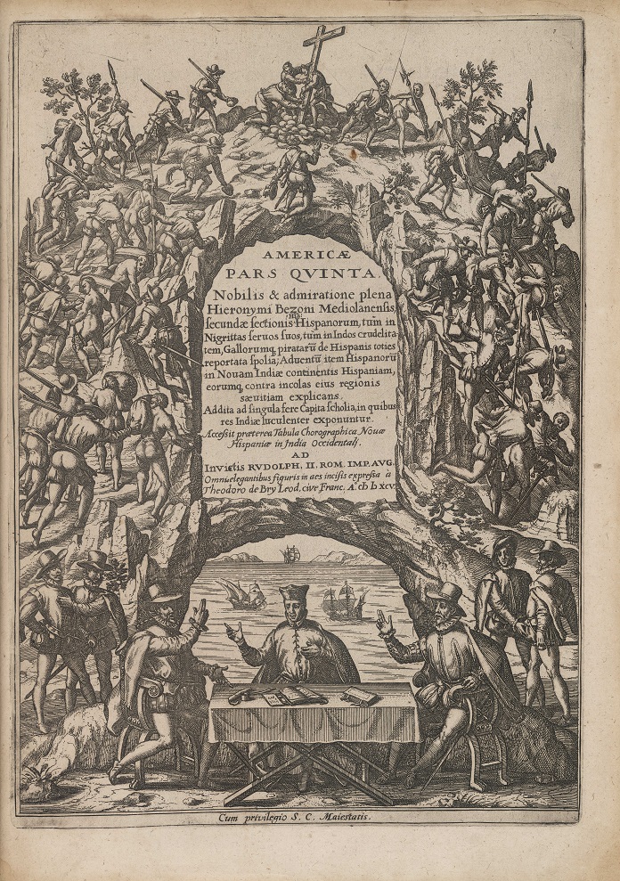
Blaeu barely touches upon the long period of conquest, defeat, and ultimately Spanish colonization. Interestingly, he makes a connection between the gradual conversion to Christianity and the nature of the indigenous peoples, who became more docile after having become Christians. The ‘barbarians’ had initially been ‘oorlogszuchtig’ [belligerent]. This description reflects the European notion of superiority. It is implied that by converting to Christianity the indigenous peoples would morally and ethically improve, making them more ‘civilized’. But was this process really as peaceful as Blaeu would suggest…?
Further reading: Benzoni, G. and W. Smyth (ed.) (2010). History of the New World, by Girolamo Benzoni of Milan: Shewing His Travels in America, From A.D. 1541 to 1556 . Surrey: Ashgate. Translated from the text originally published at Venice, 1572. The supplementary material consists of the 1857 annual report. This is a digital edition of the volume first published in 1857.
West Africa, by Famke Visser
• Title of Map / Text: NIGRITARVM REGIO / ’t Landt der Mooren Oft Swarten
• Koeman, Atlantes Neerlandici, Vol. II, nr. 8750:2
There was significant interaction between the regions encompassed by the Region of the Blacks, which is present-day West Africa, and European seafaring nations in the seventeenth century. In the fifteenth century, Portuguese explorers were the first Europeans to make contact with West African coastal regions. This is clearly reflected in the place names Blaeu uses in his map of the region. In the early seventeenth century, the Dutch also started to settle in West Africa. From then onwards, the region became a hub in the Transatlantic Trade Route, a triangular trading route that joined the Americas, Africa, and Europe together.
In his description of West Africa, Blaeu focuses heavily on the region’s natural history, devoting a number of pages to its physical features, such as the landscape and rivers. At the time, Blaeu’s contemporaries were particularly interested in discovering and confirming the source of the Nile River. Some scholars speculated that the Nile River and the Niger River might be interconnected due to their similar seasonal flooding patterns. Blaeu echoed this hypothesis in his description of the region.
The name of the region might sound inappropriate to our modern ears, but it simply reflected the European perception of West Africa’s inhabitants based on their physical appearance. That said, interestingly, the Atlas Maior only occasionally refers to the fact that the colour of the locals’ skin is ‘peckswart’ [jet black].
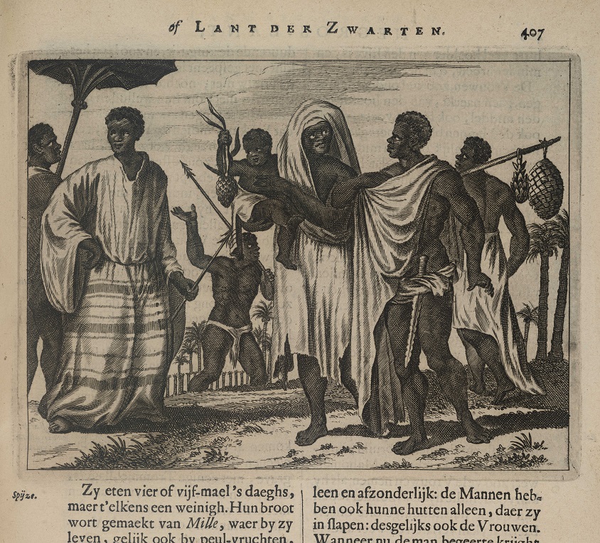
Another relatively prominent theme in Blaeu’s description of West Africa is religion, or the alleged lack thereof. The people of Nubia (a region encompassing parts of what is now Egypt and Sudan), for instance, were described as Christians, while stressing that their form of Christianity was entirely different from European Protestantism. For his information about West Africa, Blaeu relied heavily on the book Della descrittione dell’Africa et delle cose notabili che ivi sono [Description of Africa and of the Notable Things Therein Contained] (1556) by traveller and writer Leo Africanus (c.1494-1554). In some passages, Blaeu quoted Africanus virtually verbatim. One of these passages is about the Kingdom of Borno where Blaeu — like Africanus before him — claims the peoples live like ‘d’onvernuftige dieren’ [ignorant beasts] due to their lack of religion.
Further reading: Cannon, K.G. (2008). “Christian Imperialism and the Transatlantic Slave Trade,” Journal of Feminist Studies in Religion, 24 (1), pp. 127–134.
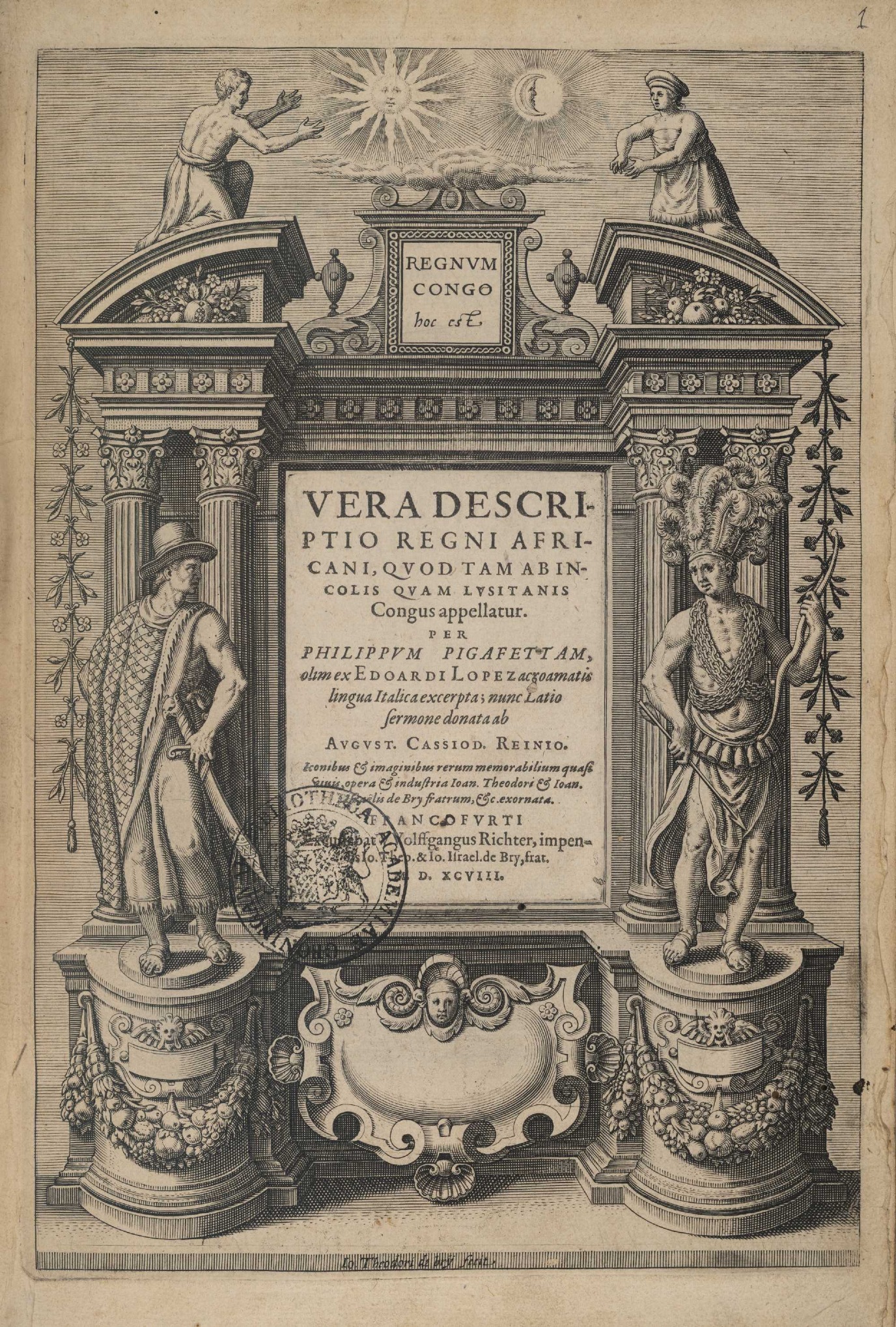
Congo, by Koen Nijensteen
• Title of Map / Text: REGNA CONGO ET ANGOLA / ’t Koninckryck Congo
• Koeman, Atlantes Neerlandici, Vol. II, nr. 8755:2
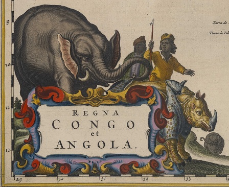
It is a long-held stereotype that it was the revived interest in, and access to, ancient Greek and Latin learning that pulled Europe out of the Middle Ages starting from the fifteenth century. This dismisses out of hand the age-old and continuous interactions between Europe and the Islamic world, which were mainly routed via the Byzantine Empire. What is true though is that the invention of the printing press unearthed sources from Antiquity that had long been considered lost. This transfer of knowledge also involved a transfer of bias.
Katherine George, for example, argued that Aristotle’s adage of (paraphrased) ‘if it ain’t Greek, it ain’t much’ formed the basis of how ethnic differences were observed in the sixteenth century. This offers a fascinating perspective on the growing number of travel journals that were published at the time. It was Amsterdam-based printer and publisher Joan Blaeu who collated information from these travel journals and published it alongside his maps in the Atlas Maior, a twelve-volume luxury product, in the 1660s.
One of the sources Blaeu used for his description of the African Kingdom of Congo was the third volume in Jan Huyghen van Linschoten’s Itinerarium (1596). This reference work formed the basis for European knowledge about the region until the nineteenth-century’s Scramble for Africa. Linschoten was a traveller who had never visited the Congo himself. He based his description on the travel journal of a Portuguese merchant: Duarte Lopes. It took Lopes only a few years to win the trust of the King of Congo, who sent him to the Pope in 1584 to seek his support in furthering the spread of Christianity and to ask him to send Catholic missionaries.
Lopes’s descriptions were exceptionally positive; he was clearly a man who felt an affinity with the region and its people. It is likely that Lopes was in the slave trade. His travel journal became a bestseller and it was soon translated into five languages. Just a century later, the increasing momentum in the transatlantic slave trade warranted a new Dutch translation. Even more interestingly, new French and English translations were published in 1881 and 1883 respectively, right at the decisive moment in the Scramble for Africa.
American scholar Richard Cole has argued, based on his study of sixteenth-century travel journals, that the European explorers’ first impressions became a defining factor in the ethos of Western culture. In that light, it is particularly poignant that Duarte Lopes’s exceptionally positive description stands in stark contrast to the suffering that went on in the Kingdom of Congo in colonial times.
Further reading: Cole, R.G. (1972). “Sixteenth-Century Travel Books as a Source of European Attitudes toward Non-White and Non-Western Culture,” Proceedings of the American Philosophical Society, 116 (1), pp. 59–67.
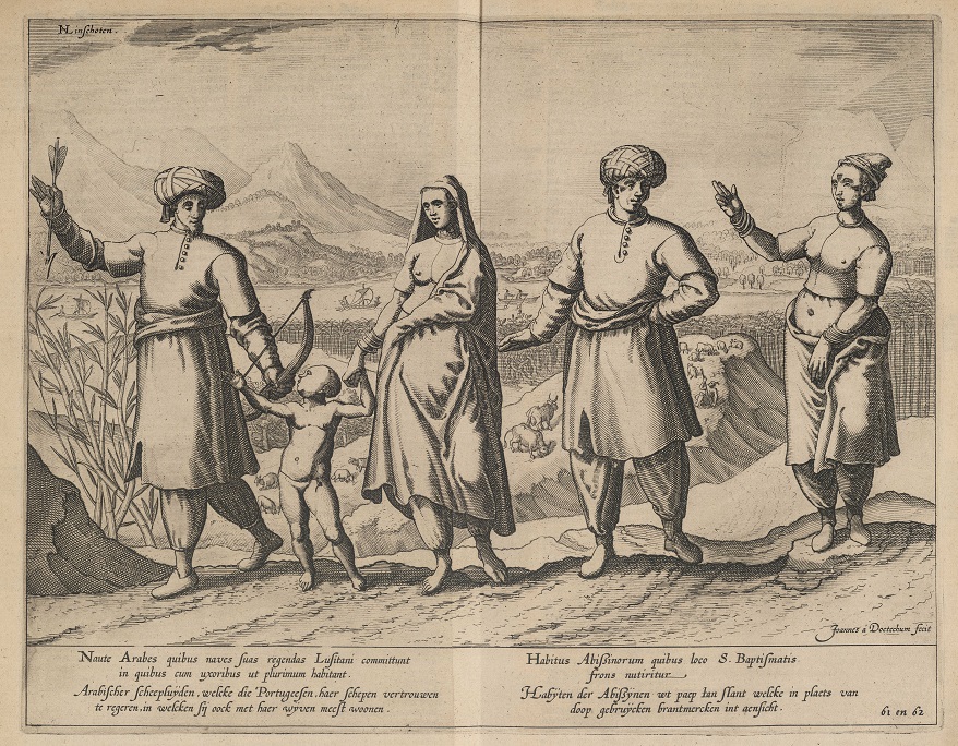
Madagascar, by Bas van der Heide
• Title of Map / Text: ÆTHIOPIA SVPERIOR VEL INTERIOR / Het Koningkryck Abissinen
• Koeman, Atlantes Neerlandici, Vol. II, nr. 8720:2
• Title of Map / Text: ÆTHIOPIA INFERIOR, VEL EXTERIOR / Neder-Æthiopien
• Koeman, Atlantes Neerlandici, Vol. II, nr. 8800:2
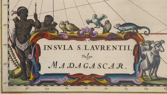
• Title of Map / Text: INSVLA S. LAVRENTII / ’t Eylandt S. Lavrens, ofte Madagascar
• Koeman, Atlantes Neerlandici, Vol. II, nr. 8900:2
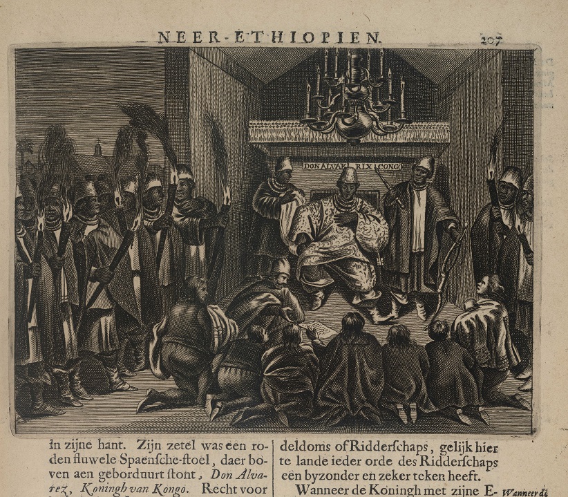
With his descriptions of the Empire of the Abyssinians, Lower Ethiopia, and the Island of St. Lawrence or Madagascar, Joan Blaeu was venturing into uncharted waters. At the time (1665), the Dutch did not have any colonies other than the Dutch Cape Colony (The Cape of Good Hope) in southern Africa and that had only been under Dutch rule for less than a decade. The rest of the region, which now roughly comprises East and South Africa and the island of Madagascar, was largely unknown in Western Europe until then. This is reflected in what the maps look like. While the coast lines are reasonably detailed, the interior is much less fleshed out.
Blaeu is concise in his descriptions. He only devotes four pages to Abyssinia and Lower Ethiopia. Yet, Blaeu did have access to more information about these regions at the time. In his Naukeurige beschrijvinge der Afrikaensche gewesten [Detailed Description of African Regions] (1668), Dutch author Olfert Dapper wrote much more extensively about Upper Ethiopia, also known as the Empire of the Abyssinians or Prester John. The two authors do agree on one thing: both Blaeu and Dapper focus on the presence of the Christian faith in the region. They both claim that this is attributable to Prester John, whom Blaeu writes is ‘eenen patriarch, die de opperste is van de Geestelijcken, die van een vroom en oprecht leven moet sijn, wel geleert, en van hoogen ouderdom’ [a patriarch who is the highest of the Clergy, who no doubt leads a devout and honest life, who is learned, and of advanced age]. Prester John was a legendary figure in European Medieval folklore and literature. He was believed to be a powerful Christian king who ruled over Ethiopia and a powerful ally in the fight against Muslims in the region. In 1681, German Orientalist Hiob Ludolf proved that Prester John was a figment of the imagination, but in the times of Blaeu and Dapper the myth was still very much alive.
Blaeu wrote nine pages about Madagascar. What captures the imagination right away is that he calls into question the name of the island. ‘Het eylandt S. Laurens wordt door de Cosmographi ofte Weereltbeschrijvers Madagascar, door d’inwoonders Madecasa, van Ptolemeus Memutheas, van Plinius Carnea, en van de Persianen en Arabiers Sarandib geheeten; maer de rechte naem is Madecasa’ [the island of Saint Lawrence is called Madagascar by cosmographers, Madecasa by its inhabitants, Memutheas by Ptolemy, Carnea by Pliny, and Sarandib by the Persians and Arabs; but its true name is Madecasa]. We find the explanation for Blaeu’s use of the European name of Saint Lawrence for Madagascar in Dapper’s work. The island was named for Lawrence Almeide, the explorer who first discovered it. Both authors also refer to classical writers such as Ptolemy, the Persians, and the Arabs, who also knew of the island. The name Madagascar did gain traction in the second half of the seventeenth century, since — as Dapper claimed — most explorers and cartographers were familiar with this name. It was based on what the local population called their island: Madecasa.
Both Dapper and Blaeu wrote about the African continent from the comfort of their Amsterdam homes. They based their writings on the knowledge of other Europeans. It would not be until centuries later that the voices of the locals, the peoples of East and South Africa, and the island of Madagascar, found their way into Western publications about these regions.
Further reading: Mukherjee, R. (2018). “People, Places, and Mobility: The Strange History of Prester John across the Indian Ocean”, Asian Review of World Histories, 6 (2), pp. 258-276.
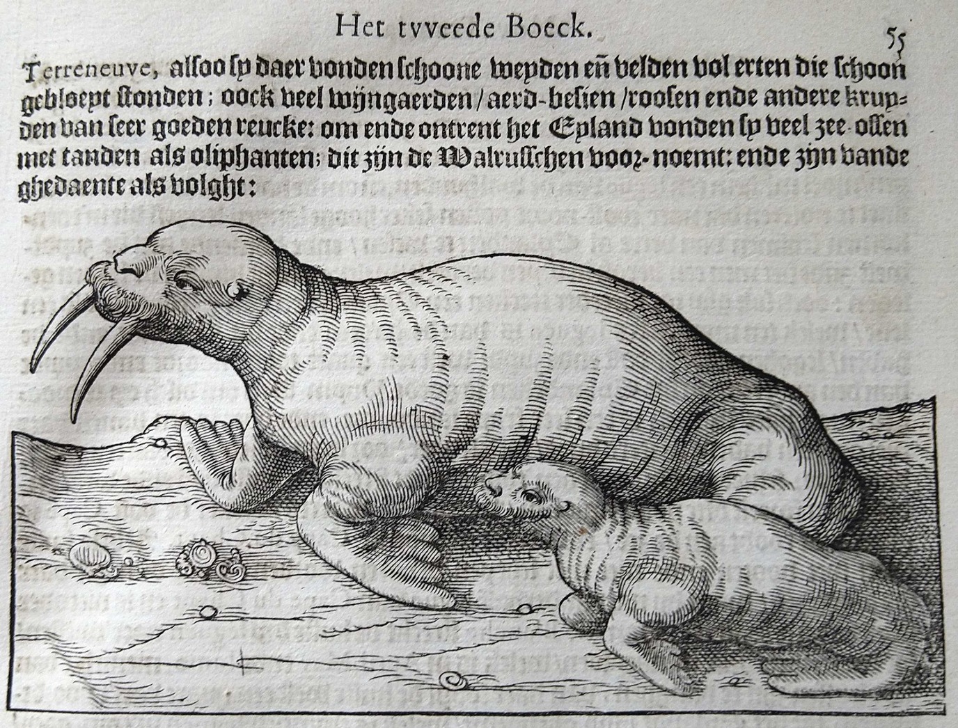
Canada, by Pascal Oskam
• Title of Map / Text: EXTREMA AMERICÆ VERSVS BOREAM / Nieu Vranckryck, met de bygelegen Landen
• Koeman, Atlantes Neerlandici, Vol. II, nr. 9130:2
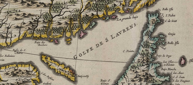
In Blaeu’s era, New France encompassed the area that is now eastern Canada and the maritime provinces, stretching from the American Northeast to Newfoundland and Labrador.
The region, which was ‘discovered’, and had been colonized, by the French, was mostly known in the late-sixteenth and early-seventeenth centuries for its rich fishing grounds. Blaeu writes: ‘Het heele eylandt is doorsneden met verscheyde rivieren, en loopende wateren, die seer goede visschen voortbrengen, onder andere salmen, alen, en, boven alle, uytnemende goede voorens’ [the entire island is teeming with rivers and streams, which produce excellent fish, such as salmon, eel, and above all, extremely good minnows]. Another important reason for the French presence was the lucrative whaling industry, in which the French welcomed the help of the local population.
Although the vast majority of his descriptions are about the natural history of New France, Blaeu also talks about the indigenous peoples, whom he describes as ‘wilden’ [savages]. Why would he call them that? The answer lies in the fact that Europeans considered any societies that differed significantly from their own as less civilized or primitive: ‘Sy bestieren sich ten meesten deel sonder wetten, sonder burgelijcke instellingen, op wijse der beesten’ [they mostly live without laws, without civil institutions, much like beasts]. The fact that these tribes did not believe in God also contributed to the distance between the Christian colonizers and the indigenous peoples. What is more, Blaeu claims that these tribes looked like barbarians and that they were far from civilized, both in their physical appearance and clothing, or lack thereof, and in their customs, and lifestyle.
Blaeu gained his knowledge about New France from two other maps of the region: Nouvelle France (Samuel de Champlain) and Nova Francia (Johannes de Laet). He used both these maps as reference works for the names of settlements, rivers, and oceans, and for information about coast lines. For details on the region’s indigenous peoples and its natural history, Blaeu mainly drew upon the knowledge of two French explorers, i.e. Samuel de Champlain (ca. 1567-1635) and Jacques Cartier (1491-1557). The fact that he repeatedly references these two authors in his descriptions should come as no surprise as Blaeu had access to their travel journals, which he touches upon towards the end of his description of this interesting region inhabited by ‘wilden’ [savages].
Further reading: : Jonathan, L.H. (2022). “Translating Empire, Translating Cartier and Léry into English: Text and Context in Comparative Narratives of Expansion and the New World”, Ilha Do Desterro, 75 (2), pp. 45-64.
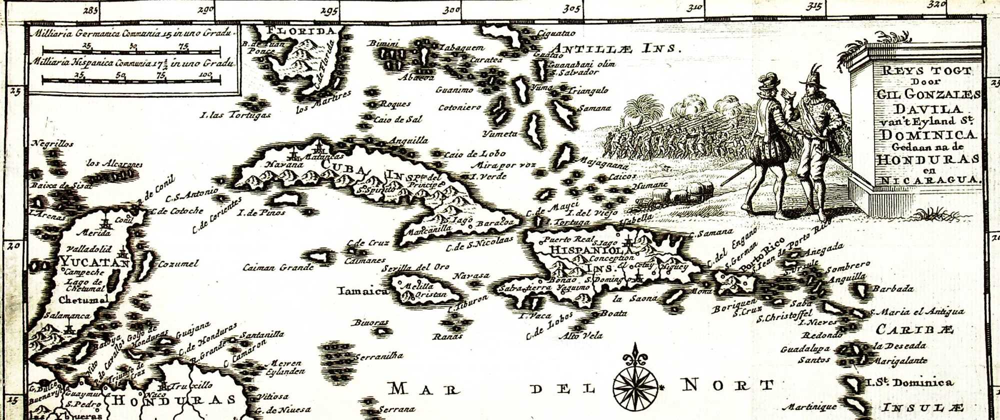
Caribbean, by Ruben Klijnsma
• Title of Map / Text: CANIBALES INSVLÆ / D’Eylanden Der Canibales
• Koeman, Atlantes Neerlandici, Vol. II, nr. 9640:2
From 1492 onwards, the westward voyages of Christopher Columbus (1451-1506) and other European explorers who followed in his footsteps literally opened up a whole New World for Europeans. The first of these voyages ended at the islands we now know as Puerto Rico, Haiti, the Dominican Republic, Jamaica, Cuba, and the Caribbean islands.
Joan Blaeu had a peculiar way of describing these islands. At first glance, his descriptions seem fairly objective. They cover geospatial, geographical, and economic aspects. That said, he also raises a number of issues that are questionable by modern-day standards, the main one being cannibalism, which — as might be expected — features prominently in the description of The Islands of the Cannibales, the present-day Caribbean islands. In his passage about this region in his Atlas Maior, Blaeu writes about ‘mensch-eters’ [man-eaters] and ‘wilden’ [savages].
Why did he describe the indigenous population like that? It was because he based his text on Johannes de Laet’s description of the West Indies. Blaeu even copied De Laet literally in some instances. De Laet talked about cannibalism, but he was not the only author to do so. The cannibals of the Caribbean feature in many travel journals and other reports too and the word cannibal even has its origins in this region.
The current consensus on this controversial theme is that there was no substantiation for depicting the population as cannibals. The stories about cannibalism in the Caribbean are mainly based on hearsay. The only ‘eyewitness accounts’ that are authentic were probably due to cultural misunderstandings, incomplete stories, and/or downright fabrications.
But the characterization of the indigenous peoples of these islands as cannibals was not without its impact. Because of it, the indigenous peoples were regarded as savages or primitives, which served to stress the Europeans’ superiority, which in turn resulted in the legitimization of the European supremacy over, and the decimation of, the local population.
Further reading: Arens, W. (1979). The Man-Eating Myth: Anthropology & Anthropophagy . New York: Oxford University Press.
North America, by Beaudine Tjerks
• Title of Map / Text: NOVA BELGICA ET ANGLIA NOVA / Nievw-Nederlandt, En Nievw-Engelandt
• Koeman, Atlantes Neerlandici, Vol. II, nr. 9310:2
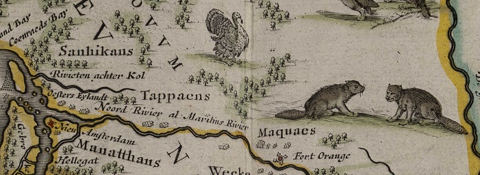
To Joan Blaeu, North America encompassed New Netherland, New England, Virginia, and Bermuda. In volume eight of his Atlas Maior, Blaeu talks about the differences between the indigenous peoples who lived in these regions, claiming that there were ‘goede’ [good] and ‘kwade’ [bad] ones.
Blaeu might well have been influenced by the Dutch and English colonists who had settled locally and wrote down their experiences with the locals in letters and travel journals. One of them was Dutch Reformed minister Jonas Michaëlius (1577-after 1638), who started serving as a clergyman on the island of Manhattan in New Netherland in 1628. Michaëlius described the Manhattans as savage and wild, and as evil people who worshipped the devil only. Blaeu too calls them a hostile nation, referring to their aggressive stance against the Dutch from the very start. Michaëlius’s experiences are clearly reflected in the Atlas Maior, although Blaeu is a little more cautious in his descriptions. He does not speak of devil worshipping, but states that the natives were hostile to the Dutch.
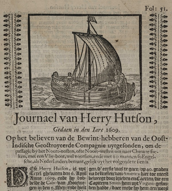
Geographer and director of the Dutch West India Company Johannes de Laet had access to many sources that copied the colonists’ perspective. De Laet based his writings on the travel journal of Englishman Henry Hudson as well as on Captain John Smith’s book The Generall historie of Virginia, New-England, and the Summer Isles (1624). It is interesting to note that Blaeu had a habit of copying De Laet’s descriptions, while Blaeu also had access to other sources. He could, for instance, have consulted Edward Winslow’s Good News from New England (1624), in which the author chronicles the consequences of infectious diseases in New England.
Unlike the other regions, Bermuda was uninhabited when settlers first arrived. It was a typical island colony. Bermuda is nonetheless relevant when studying the experiences of colonists in Blaeu’s publication. The settlers appropriated the island by naming animals, based on their appearance and behaviours. Settlers also deemed it important to introduce vegetables and plants from their home countries or other colonies to Bermuda. Although Blaeu does not focus much on appropriation by naming, he does discuss crop planting.
It could be argued, therefore, that Blaeu was selective in the information he decided to either include or exclude in his Atlas Maior. Blaeu copied a lot of information from De Laet’s book, but that is not to say that other colonists did not contribute any information, albeit indirectly.
Further reading: Waterman, K.J., J. Jacobs en Ch.T. Gehring. (2009). Indianenverhalen: de vroegste beschrijvingen van Indianen langs de Hudsonrivier (1609-1680) . Zutphen: Walburg Pers.
Florida, by Phaedra Krol
• Title of Map / Text: NOVA HISPANIA ET NOVA GALICIA / Niev Spanjen
• Koeman, Atlantes Neerlandici, Vol. II, nr. 9510:2
Spanish Florida, which was part of New Spain in the seventeenth century, is the area that is known today as the state of Florida in the United States. At its height, New Spain encompassed Central America as a whole, but the Atlas Maior limits the region to the present-day southern United States and Mexico.
The Europeans encountered a plethora of plants and crops in New Spain that were previously unknown to them and that looked nothing like what they had at home. Blaeu therefore gives detailed descriptions of the local flora, focusing in particular on their medicinal and other uses.
But more interesting than the local flora and fauna were the people who lived in Florida and New Spain. In his atlas, Blaeu identifies and describes the differences between the different indigenous peoples. He discusses the large-scale wars the chiefdoms of Florida wage against each other and the different languages spoken in New Spain. While acknowledging that the region is allegedly varied in terms of cultures and societies, he labels all indigenous groups as ‘Indians’, stripping away the diversity of their societies and cultures.
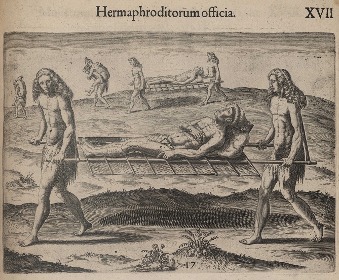
In his descriptions of the appearance and the culture of the indigenous peoples, Blaeu mainly stresses how they are different from Europeans. He writes that the Florida population is dark-skinned due to a combination of ritual skin painting with special oils and the heat of the sun. Women doing — what Blaeu perceived to be — a man’s job are labelled as ‘hermaphrodites’.
About the local Florida religion, Blaeu writes: ‘Sy en hebben geen kennis van Godt ofte eenige religie, uytgenomen wat sy sien, als de Sonne en Mane’ [they do not know God or any religion, except for what they see, such as the sun and the moon]. He refers to their priests as wizards and fortune-tellers. His dislike of ‘pagan god worshipping’ in New Spain is reflected in the following passage: ‘wel ses duysend kinderen van beyde sexen jaerlijcks gedoodt, en den af-goden opgeoffert wierden’ [more than six thousand children of both sexes are killed every year and sacrificed to the pagan gods].
Despite the diversity of the many indigenous peoples of Central America, which is partially acknowledged in the Atlas Maior, all of them are lumped together as a single group of people who clearly look different from Europeans and who have a totally different culture from what is customary in Europe.
Further reading: Botta, S. (2013). Manufacturing Otherness: Missions and Indigenous Cultures in Latin America . Newcastle upon Tyne: Cambridge Scholars Publishing.
Honduras, by Casper Colenbrander
• Title of Map / Text: YVCATAN ET GVATIMALA / Yvcatan en d’Audientie van Gvatimala
• Koeman, Atlantes Neerlandici, Vol. II, nr. 9550:2
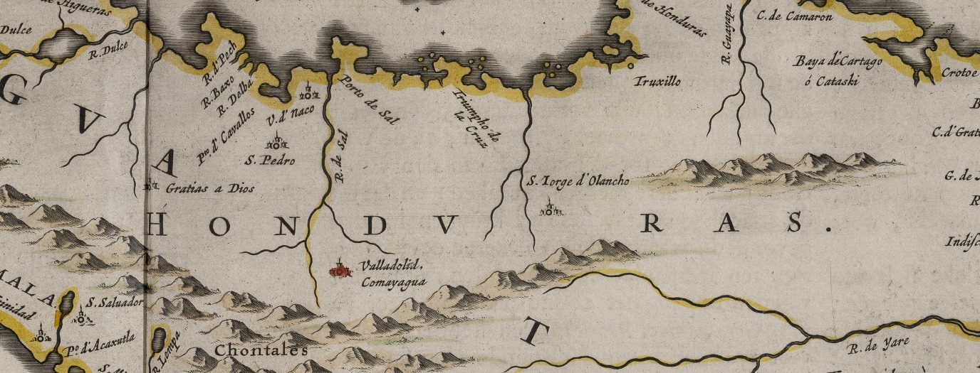
Joan Blaeu’s Atlas Maior was one of the most expensive and coveted books that was available in the seventeenth century. It was a lavish item that only the cream of the crop of the European elite could afford: from rich Amsterdam merchants to the Russian tsar. Unlike today’s atlases, the Atlas Maior was not a reference work; it was a luxury object meant for display.
That said, the Atlas Maior is definitely a great source of knowledge, as it has hundreds of maps and thousands of pages of text that describe virtually the entire planet as known at the time. Blaeu offers us a glimpse of how seventeenth-century Europeans looked at the rest of the world. The only problem is: Blaeu hardly referenced his sources.
Omitting sources is a big no-no in academia today, but it was not unusual in Blaeu’s day and age. It is possible, however, to trace back his sources. His description of Spanish colony Honduras, for instance, was copied, almost verbatim, from the works of Dutch West India Company director Johannes de Laet and from the books of Jan Huygen van Linschoten. Today, we would call that plagiarism.
Taking a more in-depth look at Blaeu’s descriptions, we see that he paints a rather biased picture. In his description of the indigenous population of Honduras, he writes that it declined considerably due to ‘de inlandse oorlogen en wederzijds doodslaan’ [domestic wars and mutual killings]. De Laet wrote much the same. Van Linschoten, however, argued that the high mortality rate in Honduras was due to slavery and exploitation, i.e. a direct result of colonialism.
Why was Blaeu more inclined to follow De Laet rather than Van Linschoten? Most likely because he did not want to offend his readers: the European elite that profited from colonialism. Blaeu did not want to alienate potential buyers of his atlas, which included the Spanish nobility and even the Spanish King, who would probably not take kindly to criticism of their colony in Honduras.
In short, Blaeu was not only vague about his sources, but he also painted a biased picture of the world. In his popular non-fiction book Guns, Germs, and Steel (1997), American author Jared Diamond goes into detail on the atrocities of European colonialism. He explains how Europe rose to dominance in past centuries thanks in large part to the colonization effort. In his book, Diamond also addresses the high mortality rate in America, which was a direct result of European colonialism. Like Blaeu, Diamond covers just about the entire planet in his book, but — unlike Blaeu — he does credit his sources.
Further reading: Diamond, J,M. (1997). Guns, Germs, and Steel: the Fates of Human Societies . New York: W.W. Norton & Company.
Venezuela, by Lieke Oude Wesselink
• Title of Map / Text: TERRA FIRMA ET NOVVM REGNVM GRANATENSE ET POPAYAN / Terra Firma, Nova Granada, En Popayan
• Koeman, Atlantes Neerlandici, Vol. II, nr. 9810:2.2
• Title of Map / Text: VENEZVELA / Niev Andalvzien, En Venezvela
• Koeman, Atlantes Neerlandici, Vol. II, nr. 9830:2.2
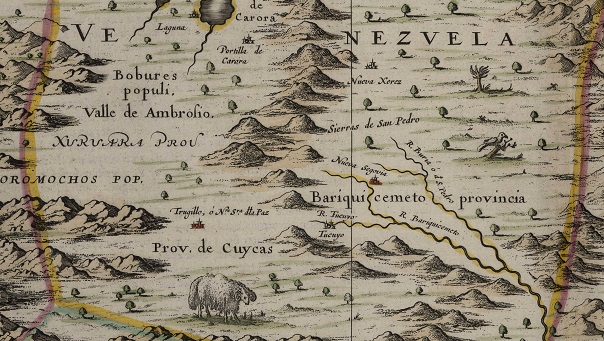
The Dutch West India Company took charge of the Dutch transatlantic trade in 1621. Unlike the Dutch East India Company in Asia, the West India Company was not in full control of the trade in this region. These maps from Blaeu’s Atlas Maior depict the areas Terra Firma and Venezuela. The Dutch had no power and played only a minor role in local trade in these regions, currently known as Colombia, the Isthmus of Panama and Venezuela and Guyana. These areas were under colonial control of the Spanish Empire, which relied on the treasure fleet it had set up in the Atlantic. Its second treasure fleet was the route to and from Terra Firma. This fleet sailed to Terra Firma to collect silver, gold, and other natural resources, and transport them to Spain. Before the Spanish put a stop to it, the Dutch were, in fact, in Venezuela for a limited time to mine salt and harvest redwood.
Since the Dutch presence in the region was sparse, Blaeu and his contemporaries were not much interested in it. Furthermore, Johannes De Laet had already published a detailed description of the region in his Beschrijvinghe van West-Indien [Description of the West Indies]. Blaeu decided to base his text of these regions largely on the descriptions by De Laet. He also used De Laet’s map of the area.
Blaeu did in fact add a more up-to-date text about Venezuela and specifically about the areas where the Dutch mined their salt. This shows that, if there was a Dutch presence somewhere, Blaeu was interested in using newer, more recent texts. In his texts accompanying the map of Terra Firma, he mainly provides information that was relevant to the treasure fleet. He names important cities on the maritime trade route, such as Nombre Dios in Panama, which was the final destination, or Cartagena, which served as a crucial port of call because it provided a secure harbour for ships to restock supplies.
Blaeu mostly describes the local population as evil or cannibalistic, but he also mentions alliances between the indigenous peoples and the Spanish. While the Spanish had originally intended to colonize the region and its inhabitants, they subsequently decided to create European enclaves.
The question remains why Blaeu specifically chose to include certain information in his descriptions in the Atlas Maior and decided to omit other available information.
Further reading: Emmer, P.C., & Gommans, J.J.L. (2020). "The Atlantic World", in: The Dutch Overseas Empire, 1600–1800, pp. 125–244
Guyana, by Sam Beereboom
• Title of Map / Text: GVIANA SIVE AMAZONVM REGIO / Gvaiana, Oft De Wilde Kvst
• Koeman, Atlantes Neerlandici, Vol. II, nr. 9840:2.2
• Title of Map / Text: BRASILIA / Brasil
• Koeman, Atlantes Neerlandici, Vol. II, nr. 9850:2B
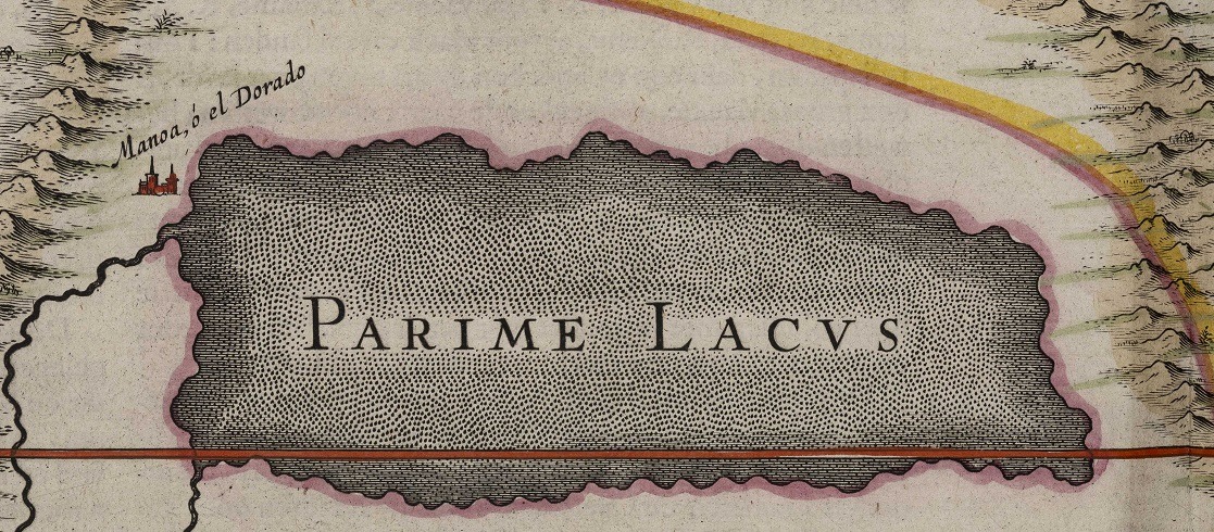
Guyana (the Wild Coast) is a region in South America, stretching between the Orinoco and Amazon Rivers. Most of the Brasil region in Blaeu’s Guyana is now part of Brazil.
The texts about these regions accompanying the maps in the Atlas Maior are somewhat paradoxical. On the one hand, the treasures of the exotic regions of the Americas were hugely admired, judging, for instance, from Blaeu’s reference to the myth of El Dorado: the Golden One. The Spanish had heard tales of an ‘Indian’ chief, covered in gold dust, who was christened in a lake they thought was in this region. From the start of the sixteenth century, they started searching extensively for this chief and the myth turned from man into city, into a country, and eventually a kingdom of gold. More tangible ‘treasures’ of the earth, such as corn, wheat, peppers, and fruits were in high demand. Blaeu also writes about useful medicinal herbs: ‘'t Sap van het blad genaemt Icari, is goedt tegen de pijn in ’t hooft’ [the juice of a leaf named Icari helps with headaches].
On the other hand, his European perspective causes him to disapprove of the regions’ indigenous peoples and their lifestyle. Blaeu mentions that they usually go around unclothed, do not have a religion, and eat human flesh. In his 1648 world map, he included an illustration of cannibals in South America. Blaeu’s descriptions of the diverse South American peoples correspond closely to those published by Johannes de Laet in 1625. They most likely served as Blaeu’s source. De Laet describes the indigenous population as violent and without any form of civilization. Given that such descriptions were prevalent in multiple contemporary sources, it is safe to assume that this was the consensus.
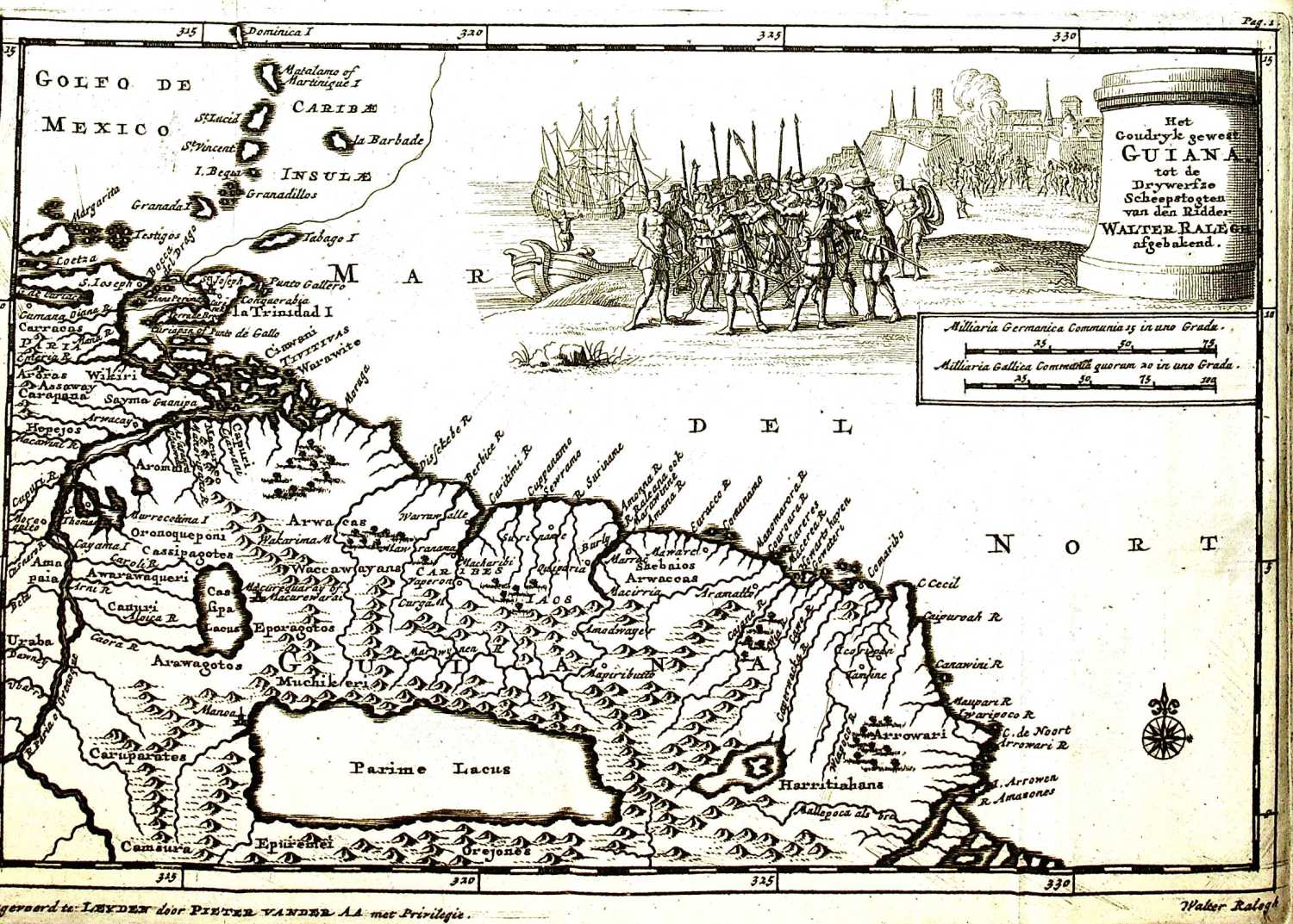
In 2012, Dutch historian Stephen Snelders wrote about the Europeans’ admiration for medicinal plant uses in the colonies and their opinion of Indians. In his book, he referred to Willem Piso (1611-1678), a prominent figure in the early history of tropical medicine. Piso argued that ‘of course’ the Europeans were in charge of deciding which medicines and medical practices were useful since the indigenous practices were rooted in a barbaric environment. This is where the crux of the paradox lies; it explains why Europeans were both interested and envious. The European settlers saw things from their own perspective. Anything found in the New World was measured against the European yardstick, both intentionally and unintentionally. Whatever passed the test, such as medicines required to survive in America, was admired and coveted. Whatever did not measure up, such as the alleged uncivilized lifestyle of the Indians, was rejected.
Blaeu’s Atlas Maior is a mirror reflecting the seventeenth-century mindset that Europe was superior to all other parts of the world. The knowledge of indigenous peoples was dismissed or appropriated without crediting its origins in scientific treatises, such as Piso’s. ‘The Other’ was not fully acknowledged. These actions contributed to Eurocentric thinking, which — to some extent — continues to this day.
Further reading: Snelders, S. (2012). Vrijbuiters van de heelkunde: op zoek naar medische kennis in de tropen, 1600-1800 . Amsterdam: Atlas.
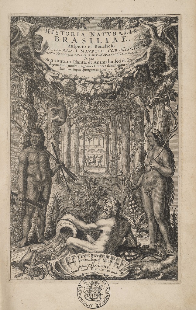
Brazil, by Niek Zeinstra
• Title of Map / Text: BRASILIA / Brasil
• Koeman, Atlantes Neerlandici, Vol. II, nr. 9850:2B
• Title of Map / Text: SINVS OMNIVM SANCTORVM / Gouvernement van De Bahia De Todos Los Santos
• Koeman, Atlantes Neerlandici, Vol. II, nr. 9855:2.2
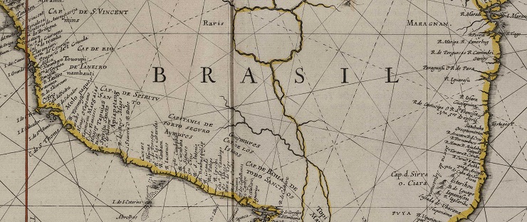
In the texts accompanying his map of Brazil, Joan Blaeu describes what is modern-day Brazil and the governorship of Bahia. His contemporaries wrote about Brazil as well. These sources show which colonial views had a lasting effect on public opinion and how they shaped the perception of Brazil.
Besides Blaeu, it was André Thevet (1516-1590) and Johannes de Laet who published representations and depictions of the indigenous peoples of Brazil in the seventeenth century. They focused specifically on three tribes: Blaeu concentrated mainly on the Petivares, Thevet on the Tupinambá, and De Laet on the Maraquites.
Blaeu claimed that, unlike other tribes, the Petivares were less ‘barbaars’ [barbarian]. He wrote that they practised body decoration, such as lip piercing, and they were less religious. They were at war with the Portuguese, they ate human flesh, and they settled in the Paraíba area. Besides the Petivares, Blaeu also wrote about the Tupinambá and the Maraquites. It is likely, though, that he got his information about the Tupinambá and the Maraquites from geographers Thevet and De Laet.
French geographer and traveller André Thevet introduces us to the Tupinambá tribe by focusing on different aspects of their life. He personally spent time with the Tupinambá to study their body decorations, hunting practices, social structures, and eating habits. Thevet details how the Tupinambá decorate their bodies with gems, body paint, and possibly tattoos, not only as a form of self-expression, but also as a display of tribal identity and ritual practice. In his travel journal, Thevet also describes the Tupinambá’s hunting practices, addressing their hunting weapons, techniques, and potential rituals. He sheds light on the Tupinambá’s social structure, including their tribal hierarchy, leadership systems, and decision-making processes. This gives us an understanding of the tribe’s social dynamic. He provides detailed descriptions of their diet, food preparation techniques, and possible rituals for food consumption. Eating human flesh is a controversial element that both Thevet and other early-modern authors have a tendency to mention.
Johannes de Laet, who — unlike André Thevet — never travelled to America himself, describes the Maraquites’ physical appearance, their clothing, and their body decorations. De Laet also provides an insight into the culture and traditions of the Maraquites, addressing their rituals for important life events, their religious practices, and the beliefs that were typical of their culture.
Further reading: Eakin, M.C. (1997). Brazil: the Once and Future Country . Basingstoke: Macmillan.
Pernambuco and Paraíba, by Noah Wubs
• Title of Map / Text: PRÆFECTVRÆ PARANAMBVCÆ PARS BOREALIS / ‘t Gouvernement van Fernambuco
• Koeman, Atlantes Neerlandici, Vol. II, nr. 9850/3:2D
• Title of Map / Text: PRÆFECTVRÆ DE PARAIBA ET RIO GRANDE / ‘t Gouvernement van Paraiba
• Koeman, Atlantes Neerlandici, Vol. II, nr. 9850/4:2D
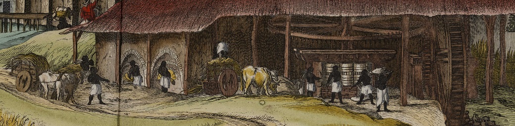
The governorships of Pernambuco and Paraíba were located in the South American northeast, in what is now Brazil. Blaeu writes extensively about the region in his texts, naming its cities, towns and villages, rivers, and natural resources. This region was known for its sugar production. Sugar was a valuable commodity at the time and this is reflected in the descriptions and illustrations accompanying the maps. Blaeu mentions different sugar plantations and refineries, and one of the illustrations in the atlas is of a sugar refinery. Sugar was produced virtually exclusively for the European market and the sugar business was highly lucrative. As a result, in the late sixteenth and early seventeenth centuries, European powers fought for control of parts of Pernambuco and Paraíba.
Blaeu mentions a number of power shifts in his text. The French were the first to settle in this region, but they were driven out by the Portuguese in 1584 with the aid of their indigenous allies. In the 1630s, the Dutch started to rise to power in the sugarcane industry by conquering the sugar-producing areas. The Dutch expansion drive accelerated with their capture of Portuguese-controlled Olinda in 1632 in an attempt to control the sugarcane trade in Brazil. But their presence would be short-lived. Fierce resistance by the Portuguese and the indigenous population forced the Dutch to leave Brazil permanently in 1654. Blaeu does not make any mention in his Atlas Maior of the recapture by the Portuguese, even though that happened more than a decade before the atlas was published. Blaeu’s map of Brazil still shows the Dutch presence as well.
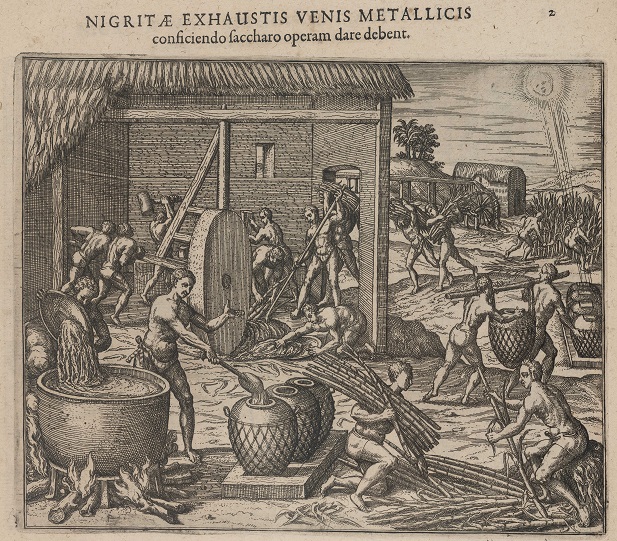
There are only a few passages about the indigenous population in the region, who are consistently referred to as ‘wilden’ [savages]. The Jewish settlers in the region go entirely unmentioned. Historical studies show that they played a prominent role in supporting the Dutch expansion in the Brazilian governorships, but Blaeu leaves them out entirely. Enslaved Africans, who worked on the sugar plantations and in the sugar mills, suffered the same marginalization. Blaeu focused only on the European presence in the region, whether French, Portuguese, or Dutch, and on the mainly profitable products that were produced there.
Further reading: Lint, J. de (2020). Pernambuco, the Dutch in Brazil 1624-1654 . Zwaag: Pumbo.
South America, by Wout Tannemaat
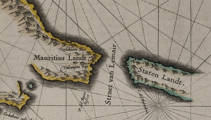
• Title of Map / Text: TABVLA MAGELLANICA / Strate Le Maire
• Koeman, Atlantes Neerlandici, Vol. II, nr. 9950:2B
The lower part of South America, present-day Argentina, Chile, Paraguay, and Uruguay, had been in Spanish hands for more than 150 years when Blaeu’s Atlas Maior was published. Conquistadores such as Francisco Pizarro (1478-1541) and his successor Pedro de Valdivia (1497-1553) caused widespread bloodshed in these areas in their effort to colonize them for gold, glory, and God – mostly in that order.
While the region is vast and diverse, Blaeu devoted a mere twelve pages to it in his Atlas. Six of these pages offer a concise description of the region’s natural history, and provide information about natural resources, about how and where the Spanish settled, and about other journeys of exploration. The indigenous population is mentioned only in passing, to demonstrate how great the power of the Spanish was or by referencing the name of a certain place in a local language. Who they were or what their cultural backgrounds entailed remains unsaid. In the description of the region, all indigenous peoples of this part of South America are labelled as ‘Indians’.
If an area did not produce gold or silver, it was irrelevant to Blaeu. In the passage about the province Río de la Plata, he does describe what the best routes to the city of Potosí were. It was general knowledge among Blaeu and his contemporaries that Potosí was one of the most significant mining sites that produced the Spanish silver that was transported to Europe. Dutch admiral Piet Hein’s capture of the Spanish treasure fleet in 1628 has until the present day a significant place in the collective memory of the Dutch.
The other six pages are maps of different areas. The most interesting of them is that of Tierra del Fuego because, while it is largely blank, it does show a variety of Spanish and Dutch names as well as an illustration of ‘Indians’ in the bottom left margin. This is a typical — and in this case, literal — demonstration of the marginalization of these regions and their indigenous peoples.
Further reading: Burkholder, M.A., & Johnson, L.L. (2010). Colonial Latin America (7th ed.). New York: Oxford University Press.
Peru, by Jorik Davids
• Title of Map / Text: CHILI / Chili
• Koeman, Atlantes Neerlandici, Vol. II, nr. 9920:2A.2
• Title of Map / Text: PERV / Perv
• Koeman, Atlantes Neerlandici, Vol. II, nr. 9820:2.2
The Atlas Maior, a fascinating work by cartographer and publisher Joan Blaeu, is more than a set of elaborately decorated maps. The descriptions accompanying these maps are a reflection of how Blaeu and his contemporaries viewed the large, mysterious world.
Blaeu’s description of the region of Chile and Peru encompasses modern-day northern Chile, Peru, Ecuador, and parts of Bolivia and Colombia. This is where the Incas and many other indigenous peoples, such as the Araucanians (Mapuche) and the Aymara, lived.
Blaeu repeatedly uses the term ‘Indians’ to refer to the indigenous population of Chile and Peru, a persistent term originating from Christopher Columbus’s mistaken belief that he had reached the subcontinent of India. Although the Incas were also regarded as ‘Indians’, it seems that they were the only people who had commanded enough respect or wonderment to be called by a specific name. The other indigenous peoples were simply labelled as ‘Indians’. Blaeu has few positive things to say about these indigenous peoples in his descriptions, but he does praise the Incas. Comments about the other ‘Indians’ mostly stress the contemporary perspective that they were different from Europeans — in a negative way.
Despite the fact that the Spanish, in their system of exploitation, made use of the indigenous population as cheap labour, Blaeu does not refer to the presence of another important group of people: enslaved workers from Africa, who had been transported to South America via the Transatlantic Trade Route. After the enslavement of indigenous peoples was prohibited in 1542, African slaves were increasingly being imported and subjected to forced labour.
Although the Dutch did not have any colonies in the region, Blaeu does mention them a few times, since they were actively raiding the Spanish colonies from their base in Maurice Town (Recife) in the first half of the seventeenth century. Interestingly, Blaeu does not refer to the Dutch Chile expedition of 1643, a large-scale attempt by the Dutch West-India Company to establish a Dutch colony in the region. This was probably deliberate on the part of Blaeu; he did not want to remind the reader of the collective Dutch trauma that this failed expedition had caused.
Blaeu mainly references the Spanish accomplishments in the region. He paints an almost romantic picture of the local riches, but leaves mostly unsaid that the Spanish dominance was the result of much bloodshed. In his descriptions, Blaeu talks about the Spanish (i.e. European) supremacy almost as a matter of course.
Further reading: Henk den Heijer (2015). Goud en Indianen – Het journaal van Hendrick Brouwers expeditie naar Chili in 1643 . Zutphen: Walburg Pers.
Moluccas, by Rozemarie Fokkema
• Title of Map / Text: MOLVCCÆ INSVLÆ CELEBERRIMÆ / Molvccen
• Koeman, Atlantes Neerlandici, Vol. II, nr. 8560:2.2
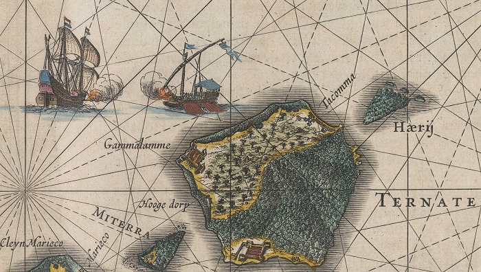
In Blaeu’s Atlas Maior, the Moluccas encompass the islands Ternata (Ternate), Tidora (Tidore), Motir (Moti), Machian (Makian), and Bachian (Bacan), currently in North Maluku. The Latin title of the map, which is Moluccae insulae celeberrimae [the world-famous islands of the Moluccas], shows that this relatively small archipelago was very well-known as early as in Blaeu’s era. The reason for its ‘fame’ was the presence of spices, some of which, such as clove, were exclusive to this part of the world. European and Asian merchants were very keen to stake their claim on the highly lucrative spice trade.
In his description of the region, Blaeu has much to say about the ‘byzondere’ [special] clove tree. He discusses extensively where clove trees grow, how they are best cultivated, and how cloves should be harvested and dried. This focus points to the relevance of the clove trade. Blaeu measures the productivity of clove trees in monetary terms, saying that they are so productive ‘dat men van eenen twee baren plukt, dat is, 1250 Hollandtsche ponden’ [that one tree will produce two bars, which is 1,250 Dutch pounds].
Blaeu devotes a large section of his description to the fact that competing foreign powers were trying to gain a foothold on the islands. He mentions that Arab merchants were trading in the region earlier and that some of the local population had adopted the Islam religion and Arabic script as a result. In addition, the presence of Dutch, Spanish, and Portuguese merchants in the archipelago led to conflicts in the late-sixteenth and the seventeenth centuries, since they all sought to establish a monopoly to control the spice trade.
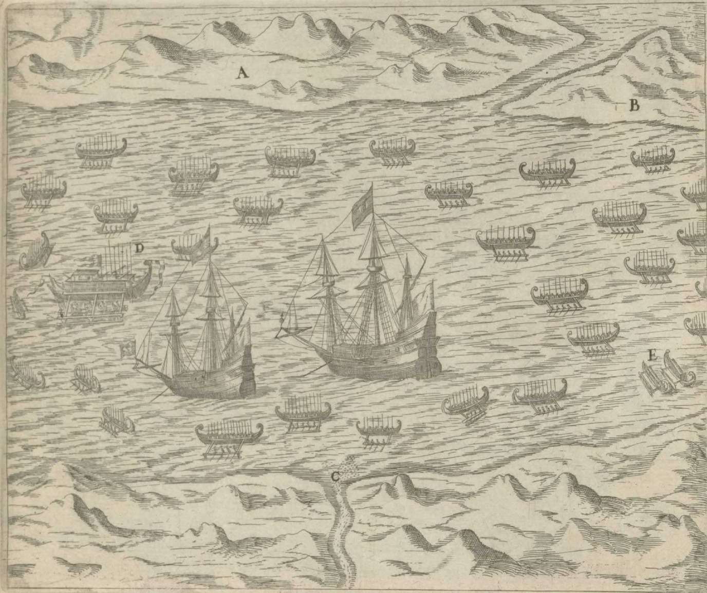
Blaeu writes about the alliances between the island of Tidora and the Portuguese, and between the island of Ternata and the Dutch. These neighbouring islands, which he claims are ‘soo na by malkanderen, dat men met een grof-geschuts kogel van d’een kust de andere kan bereyken’ [so close to each other that a cannon ball fired from one coast will reach the other], were constantly at war with each other. Conflicts were mostly fought out at sea, with Moluccans using kora koras, a type of traditional outrigger canoe that is depicted on Blaeu’s map.
At the time of publication of the Atlas (1664), the Dutch East-India Company (VOC) had defeated the Portuguese and the Spanish, and had managed to establish a monopoly on the spice trade. Information about VOC-controlled territories, such as the Moluccas, was sensitive because it might give away potentially useful knowledge to competitors. What is noteworthy in this regard is that Joan Blaeu was the VOC’s official cartographer, which meant that he was basically bound to secrecy. This makes the inclusion of a map and a description of the Moluccas in the Atlas Maior highly unusual and deserving of further research.
Further reading: Storms, M. “Geheimhouding bij de VOC? De dubbele petten van Blaeu en van Keulen,” Caert Thresoor, 38 (1), pp. 14-25.
Turkey, by Gijs de Vries
• Titel of Map / Text: NATOLIA QVÆ OLIM ASIA MINOR / Natolia, Eertijdts kleyn Asien
• Koeman, Atlantes Neerlandici, Vol. II, nr. 8110:2
• Titel of Map / Text: TERRA SANCTA / Palæstina, ofte ‘t Landt Van Beloften
• Koeman, Atlantes Neerlandici, Vol. II, nr. 8150:2.2
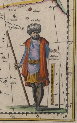
The Turkish or Ottoman Empire was an area encompassing multiple regions on three continents: Africa, Asia, and Europe. In his Atlas Maior, Blaeu specifically covers two of these three regions, i.e. Natolia and The Holy Land, or Land of the Promised, formerly Palestine. Natolia corresponds mostly with the current Asian side of Turkey, and Palestine encompasses parts of South Lebanon, Israel, and the Palestinian territories. In Blaeu’s era, these regions were under Ottoman rule. The Ottomans were usually referred to as ‘Turks’, which was also an umbrella term for Muslims in the early-modern era.
Blaeu’s descriptions of Turkey and Palestine focus heavily on religion. He speaks of ‘spottelijcke sotternyen’ [ridiculous silliness] when addressing the origin of Islam. He is also dismissive of rituals and customs which he regards as outlandish, such as polygyny (men taking more than one wife), since monogamous marriages were the norm in Christian Europe.
Whereas Blaeu is mostly critical and dismissive of religion in the Ottoman Empire, the religious passages about Palestine reflect a strong spiritual connection with the area. The Holy Land or Land of the Promised was the cradle of Christianity after all. The map is full of biblical references and Blaeu describes in great detail the places mentioned in the Bible, such as Sodom and Gomorrah, as well as the place where the Last Supper took place.
The focus on religion in the descriptions in Blaeu’s Atlas Maior and the underlying reasons for this focus merit further research.
Further reading: Brummett, P. (2015). Mapping the Ottomans: Sovereignty, Territory, and Identity in the Early Modern Mediterranean . Cambridge: Cambridge University Press.
Arabian Peninsula, by Timo Middelbos
• Title of Map / Text: ARABIA / Arabien
• Koeman, Atlantes Neerlandici, Vol. II, nr. 8180:2
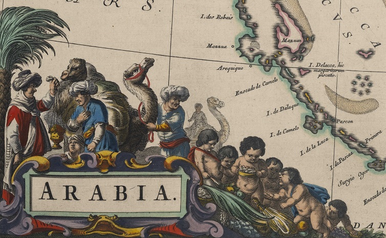
‘Het is byna vierkant, en is meer dan een Half-eylant; want de zee bespoelt het aen drie sijden’ [It is almost square and more than a peninsula; because it has a sea on three sides]. This is how Blaeu describes the geography of the Arabian Peninsula in his Atlas Maior. Arabia was divided into three parts in the seventeenth century: Arabia Petrea (rocky), Arabia Felix (fortunate), and Arabia Deserta (empty).
Fortunate Arabia was known for its riches, trade, and fertile land. Blaeu describes the coastal Arabs as ‘van schoonder gestalte, en veel aangenamer dan d’ andere Arabiers’ [better looking and much more pleasant than the other Arabs]. Blaeu also claims that the coastal dwellers were intelligent, eloquent, and adept at poetry and medicine. This shows a certain level of respect and admiration for the cultural and intellectual developments in Fortunate Arabia. That said, there is a complete lack of respect or admiration in Blaeu’s description of the other regions. Blaeu consistently uses derogatory terms to describe the Arabian population, calling them ‘leelijck, mager, droogh en bruyn, als door de hitte gebrant’ [ugly, skinny, dry, and having brown skin as if burnt by the heat]. He also says that ‘sy hebben een vrouwelijcke stem, en swarte oogen, met een fel en wreet gelaet’ [they have a feminine voice and black eyes in fierce and cruel faces].
What would be the reason for these negative descriptors? A few reasons come to mind. First of all, the Arabs were nomadic people, a very different lifestyle from the Europeans’ sedentary lives. Their clothes (‘schamel’ [shabby]) and the Arabian trading practices (‘roofachtig’ [extortionate]) were also described dismissively. But, first and foremost, it is because of their religion that the Arab peoples are criticized in Blaeu’s Atlas. This sentiment dates back to the Middle Ages when Islam originated and came into conflict with Christianity soon after, initially in the Near East, but — in the eighth and ninth centuries — also on the Iberian Peninsula and as far north as France. In Blaeu’s time, it was mostly the threat of the Ottomans, in Central Europe and the Mediterranean, that contributed to the negative view toward Islam and Muslims.
This explains Blaeu’s seemingly ambivalent opinion, i.e. both admiration and dislike, in his description of the people of Arabia.
Further reading: Varthema, L. de, Jones, J. W., Badger, G.P. (1970). The Travels of Ludovico di Varthema in Egypt, Syria, Arabia Deserta and Arabia Felix, in Persia, India and Ethiopia, a.d. 1503 to 1508 (Reproduction of the Works issued by the Hakluyt Society, 32). New York: Franklin.
Central Asia, by Jeroen Bos
• Title of Map / Text: TARTARIA SIVE MAGNI CHAMI IMPERIVM / Tartarien Ofte Het Rijck van de Groote Cham
• Koeman, Atlantes Neerlandici, Vol. II, nr. 8050:2
In Blaeu’s time, Tartary, or the Kingdom of the Great Khan, encompassed large parts of Central Asia, stretching from Turkey to Siberia and China. The region was not at all clearly delineated. Blaeu’s references to the great khans of the past, such as Genghis (1162-1227) and Kublai (1215-1294), give rise to the belief that he relied on old sources, such as Roman author Pliny the Elder (23-79) and Venetian traveller and merchant Marco Polo (1254-1324). The map shows the fictitious island of Tazata in the Arctic Ocean, stating that it was mentioned by Pliny. Except for the tiny ‘Staten Eylant’ (Island of the States General) in the top left corner of the map (named by the Dutch during the late-sixteenth-century Arctic expeditions), all names of towns, areas, lakes, and rivers on the map were copied — some in corrupted form — from Marco Polo’s Il Milione (in English commonly called The Travels of Marco Polo).
Examples of place names Blaeu copied one-on-one from Marco Polo’s book include the ‘voortreffelijcke Paleys des Grooten Chams Cublai’ [magnificent palace of the Great Kublai Khan], located in Ganda, the present-day Shangdu, China. Polo claimed that black chickens with ‘hayr als swarte katten’ [hair like black cats] were roaming around the city of Quelinfu (the current Jianzhou), also in China.
These chickens may have been outlandish, but nothing caused more wonderment than the ‘bonaretz’ (or barometz), a mythical creature that was half plant half animal. It was described as having the appearance of a lamb or sheep growing from the ground. The bonaretz was said to eat the grass and herbs around it; once that was gone, the animal part of it died. European scholars continued to believe in this mythical creature and write about it in natural-history publications as late as into the nineteenth century. After that, the myth was dispelled.
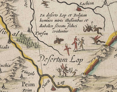
Blaeu also depicted mythical creatures on his map. In the area of the Lop Desert in the Xinjiang region, he drew in a set of demonic figures. Marco Polo claimed that, here, travelling merchants needed to make sure that they were not isolated from their group because, once they were alone, they would fall victim to the spirits and demons of the desert.
The question remains why Blaeu relied on Pliny and Polo. Did he not have access to more up-to-date information about the region? He definitely did, in both published and unpublished form. It was Amsterdam-based statesman and writer Nicolaes Witsen (1641-1717) who updated all available information on the region in a much more detailed map (1690) and in his book Noord en Oost Tartarye [North and East Tartary] (1705).
Further reading: Peters, M. (2010). ‘Mercator sapiens’ (de wijze koopman): het wereldwijde onderzoek van Nicolaes Witsen (1641-1717), burgemeester en VOC-bewindhebber van Amsterdam . Amsterdam: Bert Bakker
| Last modified: | 19 June 2025 11.37 a.m. |