
Moving Beyond the Checklist: Leveraging Public Participatory GIS for Social Performance of Indonesian Geoparks
| Date: | 16 March 2023 |
| Author: | Luthfi Muhamad Iqbal |

Geoparks: Intervention for Sustainable Local Development
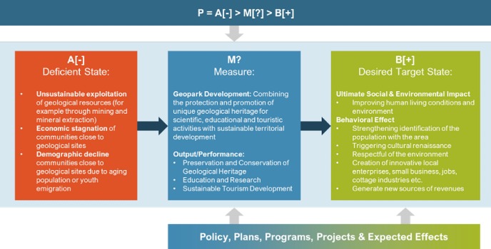
Geoparks are territories with defined geographical boundaries that aim to protect and promote unique geological heritage while fostering sustainable local development. The birth of the Geoparks concept represents an innovation, positioning sustainable territorial development efforts through the protection and promotion of geological heritage for scientific, educational, and touristic activities as a presupposition for a successful conservation strategy (Zouros, 2004). This concept emerged from the realization that the initial conditions of non-renewable exploitation of geological resources, such as mining and mineral extraction, were not sustainable.
The development of Geoparks is expected to facilitate a shift towards a more sustainable economic model centred on geo-tourism, which can revitalize local communities surrounding geo-sites, which often suffered from economic stagnation and demographic decline (Keever & Zouros, 2005; Frey, 2021). Geoparks are expected to generate socio-economic benefits, such as job creation, revenue generation, and environmental and cultural appreciation (Eder & Patzak, 2004). Figure 1 summarizes the potential for Geopark Development to address underlying issues and generate desired policy effects using the framework developed by Schönwandt et al. (2013) and Crabbé and Leroy (2008).
Community Participation and Social Issues around Geopark Development
While conceptually, Geoparks have a community-centred nature, involving local communities in the planning, implementation, and evaluation of Geopark projects remains a challenge. Recent research has explored the potential of Public Participatory GIS (PPGIS) in human-natural system research, including national park planning, management, and evaluation (Brown & Weber, 2011; Pietilä & Fagerholm, 2018; Johnson, et al., 2022; Ancona, et al., 2022). However, GIS application in Geopark management in Indonesia is limited to one-way information and education (Darsiharjo, et al., 2019). Furthermore, case studies of three geopark sites have identified unintended social impacts on geopark development (Sagala, et al., 2018; Ristiawan, et al., 2023), as outlined in Figure 2.

To ensure the success and sustainability of Geopark projects in Indonesia, it is imperative to enhance community participation and consider the social impacts of such initiatives. Therefore, this essay endeavours to investigate the potential of Public Participatory GIS in facilitating effective social impact management (PPGISIM) for Indonesia Geoparks.
Why Communities Matter in Geoparks Planning?
Communities play a crucial role in Geoparks, as recognized by UNESCO's criteria (2015), particularly criterion (v). Geoparks are required to involve local communities and indigenous peoples as key stakeholders and develop a co-management plan that addresses their social, economic, and cultural needs while protecting the landscape. The involvement of all relevant local and regional actors and authorities is recommended, and both science and indigenous knowledge should be included in planning and management. Despite the importance of community involvement, the role of communities and their societal embedding in Geoparks remain largely absent in geopark research. Stoffelen (2020) identifies three critical reasons why local communities are essential for the Geoparks Development (Figure 3):

Moving Beyond Checklist! Leveraging Public Participation GIS for Optimal Social Performance in Geopark Development
Social Impact Assessment is defined as “the process of analysing, monitoring, and managing the intended and unintended social consequences both positive and negative, of planned interventions and any social change processes invoked by those interventions” (Vanclay, et al., 2015). These interventions may take the form of policies, programs, plans, or projects, and in the context of this discussion, the planned intervention is the development of a Geopark. Traditionally, SIA has been viewed as the identification of social impacts to fulfil legal approval. However, more recently, SIA has been recognized as encompassing a full set of activities known as Social Performance, which involves a more comprehensive approach to managing the social aspects of planned interventions (Vanclay, et al., 2015).
In Indonesia, Social Impact Assessment (SIA) was initially seen as part of the Environmental Impact Assessment (EIA), which only focused on the biophysical environment. However, this understanding has evolved to include social aspects, such as the second and third-order impacts, as well as direct social impacts (Suprapto, 1990). Unfortunately, community involvement in EIA is still limited to reacting, suggesting, and responding to information from project proponents or attending public consultations held by them that are documented in a result and evaluation of community involvement (2021).
Prior to 2017, there was no dedicated legal framework for Social Impact Assessment (SIA) in Indonesia. However, the introduction of Presidential Regulation No. 56/2017 marked a significant milestone in the development of a specific legal basis for managing the social impact of land provision for national strategic projects (2017). This regulation was later broadened through Perpres 62/2018 to cover national development (2018) and then expanded even further through Perpres 52/2022 to encompass all development for the public interest (2022). Despite these advancements, the current regulations remain narrowly focused on managing the social impact related to land acquisition and resettlement, rather than a more comprehensive approach to social impact management.
Within the context of Geopark Development, the management of social impacts is not explicitly stated in any regulatory framework. However, one clause in the Ministry of Tourism Regulation No. 2/2020 mandates the management of the development impacts of Geoparks as tourist destinations within the framework of "Disaster Mitigation" (Kemenparekraf/Baparekraf, 2020). Despite this, active involvement of local communities in conservation, education, and the development of sustainable local economic activities is inherently mandated in the definition of Geopark itself, as stipulated in Presidential Regulation No. 9/2019 on Geopark Development (2019), Ministry of Energy Regulation No. 31/2021 on the Establishment of National Geoparks (ESDM, 2021), and Ministry of Planning Regulation No. 15/2020 on the National Action Plan for Indonesian Geopark Development 2021-2025 (Bappenas, 2020). Figure 4 outlining the proposed framework for identifying Social Impacts from Geopark Development adapted from Vanclay, et al (2015).

While it is important to engage local communities in Geopark development, such efforts may fall short of their intended purpose without proper operationalization of social impact management and meaningful public participation. To ensure the true purpose of sustainable local development is achieved, it is necessary to go beyond mere legal requirements. Figure 5 outlines a full set of Social Performance activities that can be leveraged by Public Participation Geographic Information Systems (PPGIS) to enhance positive social impacts and mitigate negative and unintended social impacts of Geopark Development.

The integration of Social Impact Assessment (SIA) and Public Participatory GIS (PPGIS) into Geopark Development planning practices is crucial for promoting sustainable local development. However, PPGIS has several limitations that must be considered (Brown, 2017):
- Firstly, mapping bias can arise depending on who participates and how participation is implemented. It is crucial to ensure that the use of PPGIS does not lead to the exclusion of groups of populations with limited access to participate in the process.
- Secondly, spatial information can be used to determine social acceptability, but there is a dilemma between achieving spatial representativeness and giving more voice to vulnerable groups. Balancing these concerns requires careful consideration and may require prioritizing certain groups or finding ways to engage more diverse perspectives.
- Thirdly, ethical concerns around spatial identification of communities should also be considered, including issues surrounding privacy and confidentiality, as well as potential negative consequences for marginalized communities.
To address these challenges, future research should move beyond SIA and PPGIS as independent processes and technical spatial tools. Instead, researchers should consider integrating them into impact analysis tools, PPGISIMP (Public Participatory GIS for Social Impact Management Plan). This approach may help leverage positive social change and deliver more equitable Geopark Development in Indonesia and worldwide.
References
----, 2017. Presidential Regulation No. 56/2017 on Management of Social Community Impacts in the Context of Land Provision for National Strategic Projects. Jakarta: LN.2017/NO.110.
----, 2018. Presidential Regulation No. 62/2018 on Management of Social Community Impacts in the Context of Land Provision for National Development. Jakarta: LN.2018/No.130.
----, 2019. Presidential Regulation No. 9/2019 on Geopark Development. Jakarta: LN.2019/No.22, Sekretariat Kabinet Republik Indonesia.
----, 2021. Government Regulation No. 22/2021 on the Implementation of Environmental Protection and Management. Jakarta: LN.2021/No.32, TLN No.6634, jdih.setkab.go.id.
----, 2022. Presidential Regulation No. 52/2022 on Management of Social Community Impacts on Land Identified as Destroyed Land in the Context of Development for the Public Interest. Jakarta: LN.2022/No.87, jdih.setneg.go.id.
Ancona, Z. H. et al., 2022. Spatial social value distributions for multiple user groups in a coastal national park, Denver: Geosciences and Environmental Change Science Center.
Bappenas, 2020. Regulation of the Minister of National Development Planning/Head of the National Development Planning Agency No. 15/2020 on the Indonesia National Action Plan for the Development of Earth Parks (Geopark) for 2021-2025. Jakarta: Ministry of National Development Planning/National Development Planning Agency.
Brown, G. & Weber, D., 2011. Public Participation GIS: A new method for national park planning. Landscape and Urban Planning, 102(1), pp. 1-15.
Crabbé, A. & Leroy, P., 2008. Policy Evaluation and Environmental Policy. In: The Handbook of Environmental Policy Evaluation. London: Earthscan, pp. 1-29.
Darsiharjo, et al., 2019. Mobile gis app for guiding geopark at unesco global geopark ciletuh palabuhanratu, indonesia. Solo, Indonesia, IOP Conference Series: Earth and Environmental Science.
Eder, F. W. & Patzak, M., 2004. Geoparks—geological attractions: A tool for public education, recreation, and sustainable economic development. Episodes, 27(3), pp. 162-164.
ESDM, 2021. Regulation of the Minister of Energy and Mineral Resources No. 31/2021 on the Establishment of a National Earth Park (Geopark). Jakarta: the Ministry of Energy and Mineral Resources.
Frey, M.-L., 2021. Geotourism—Examining Tools for Sustainable Development. Geosciences, 11(1).
Johnson, M. S., Adams, V. M., Byrne, J. & Harris, R. M. B., 2022. The benefits of Q + PPGIS for coupled human-natural systems research: A systematic review. Ambio, Volume 51, pp. 1819-1836.
Keever, P. J. M. & Zouros, N., 2005. Geoparks: Celebrating Earth heritage, sustaining local communities. Episodes, 28(4), pp. 274-278.
Kemenparekraf/Baparekraf, 2020. Regulation of the Minister of Tourism and Creative Economy/Head of the Tourism and Creative Economy Agency No. 2/2020 on Technical Guidelines for Geopark Development as a Tourism Destination. Jakarta: Ministry of Tourism and Creative Economy/Tourism and Creative Economy Agency.
Pietilä, M. & Fagerholm, N., 2018. A management perspective to using Public Participation GIS in planning for visitor use in national parks. Journal of Environmental Planning and Management, 62(7), pp. 1133-1148.
Ristiawan, R., Huijbens, E. & Peters, K., 2023. Projecting Development through Tourism: Patrimonial Governance in Indonesian Geoparks. Land, 12(223).
Sagala, S., Rosyidie, A., Sasongko, M. A. & Syahbid, M. M., 2018. Who gets the benefits of geopark establishment? A study of Batur Geopark Area, Bali Province, Indonesia. Bandung, IOP Publishing.
Schönwandt, W. et al., 2013. Deficient State. In: Solving Complex Problems. A Handbook. Berlin: Jovis, pp. 16-92.
Stoffelen, A., 2020. Where is the community in geoparks? A systematic literature review and call for attention to the societal embedding of geoparks. Area, Volume 52, pp. 97-104.
Suprapto, R. A., 1990. Social Impact Assessment and Planning: The Indonesian Experience. Impact Assessment, 8(1-2), pp. 25-28.
UNESCO, 2015. Statutes of the International Geoscience and Geoparks programme (IGGP). Paris, UNESCO. General Conference, 38th, 2015.
Vanclay, F., Esteves, A. M., Aucamp, I. & Franks, D. M., 2015. Social Impact Assessment: Guidance for Assessing and Managing the Social Impacts of Projects. s.l.:International Association for Impact Assessment (IAIA).
Zouros, N., 2004. The European Geoparks Network: Geological heritage protection and local development. Episodes, 27(3), pp. 165-171.
About the author
Student of the Research Master Islands and Sustainability track